Copehill Down on Salisbury Plain in Wiltshire, England, may look like a typical English village, but on closer inspection something doesn’t quite look right. The architecture is rather German, and there is not a single living soul in sight. Copehill Down is actually a fake village built by the British army during the tail end of cold war to practice their urban warfare skills and close quarters fighting. Called a 'FIBUA' (Fighting In Built Up Areas) village, Copehill Down is just one of the handful of villages scattered around the U.K., Europe and the U.S.
copenhill-down-6
Fighting in urban areas is very different from combat in the open at both the operational and tactical level. Presence of civilians is just one of the factors. The complexity of the urban terrain limits field of view while enhancing opportunities for concealment and cover for defenders including easy placement of booby traps and snipers. Besides, some civilians may be difficult to distinguish from the enemy.
Copehill Down was built in 1988 to resemble a German village in Bavaria, to provide troops with a simulated backdrop when training for operations in European theatres including the Cold War, the Balkans and Northern Ireland. In recent years the facility was expanded to include a Shanty Town made up of cargo containers stacked and laid out in rows of tightly packed streets, to provide an additional training area that more closely resembles the Army's current operation in Afghanistan and Iraq. A couple of train bogies, a destroyed helicopter, and some burnt cars were added just for good measure.
Access to Copehill Down is generally restricted, however the facility has been used for regular airsoft wargaming by certain British airsoft event organizers and Historical Reenactment societies, which take part in Private Reenactment Battles.
copenhill-down-8
copenhill-down-4


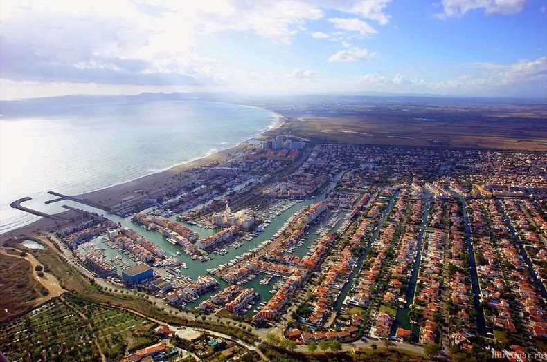
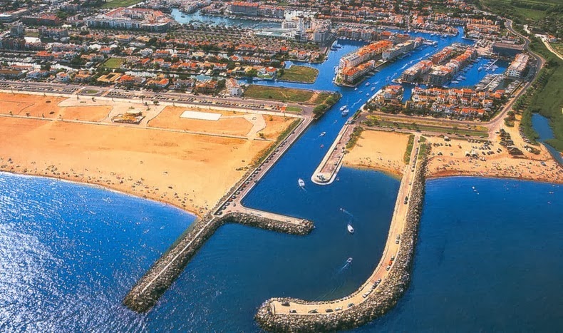
Empuriabrava is an unusual town on the coast of Girona, the Costa Brava in Spain. It is one of the largest residential marina in the world with more than 40 km of navigable canals, 5,000 boat moorings and home to 7,800 local residents, which swells to 80,000 at the height of the summer season. Empuriabrava is often called the Venice of Spain.
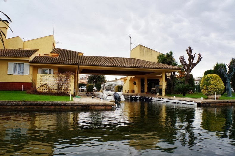
Empuriabrava was originally built on a swamp, and was transformed into a touristic community during the 1970s. The place is a major, upmarket tourist destination for the rich and the privileged. It is particularly popular with Germans and the French, and to a much lesser extent, Dutch and British visitors as well. Most of the city is made up of pretty private homes built in classic Mediterranean style. Nightlife is vibrant with bars, discos, and a range of restaurants catering to foreigners eager to enjoy familiar food. Many tourists and day-trippers rent sailboats or motorized boats, or at the very least take a canal boat tour.
empuriabrava-15
In Empuriabrava, the sun shines almost 300 days a year. There is a magnificent wide sandy beach, several kilometers long that’s popular among sunbathers and swimmers, as well as to those who like to engage in all sorts of water sports. In addition, Empuriabrava is a paradise for skydivers. Just north of the town is Europe’s largest and busiest Skydiving Centre - Skydive Empuriabrava, considered to be among the three best in the world.
empuriabrava-5
empuriabrava-11
empuriabrava-12
empuriabrava-9
empuriabrava-1
empuriabrava-3
empuriabrava-6
empuriabrava-7
empuriabrava-8
The island of Montecristo is one of the seven islands that make up the Tuscan Archipelago in the Tyrrhenian Sea, about 60 km from the coast of Italy. Made famous by Alexandre Dumas’ classic novel of betrayal and revenge - “The Count of Monte Cristo”, the uninhabited island is shrouded with mysteries and numerous legends that surround this place. Until very recently, Monetcristo remained strictly off-limits to tourists after it was declared a nature reserve more than 40 years ago. Today, only a thousand tourists are allowed to visit the island each year under a tightly-controlled permit system.
montecristo-island-13
The caves of Montecristo was once home to several hermits who escaped the vandals of Genseric in the 5th century AD. It was these hermits who christened the island "Mons Christi", from which the modern name is derived. At the beginning of the 7th century, the Monastery of St. Mamilian was founded and a chapel was built in the very cave where the saints took shelter. Over the years, donations from several noble families made the monastery powerful and rich.
In the 1550s, the notorious Turkish pirate Red Beard and his successor Dragut, seized the monastery on Montecristo and set up their base giving rise to the legend of treasure hidden on the island. Dragut is thought to have accumulated vast wealth which he had stashed away in a hidden grotto somewhere on the island. Over the centuries many have attempted to find Dragut’s treasures, but no one has ever been successful. It was this legend of hidden treasure that inspired Alexandre Dumas to write The Count of Monte Cristo.
Dumas arrived on the island in 1842, in the company of Napoleon Bonaparte's nephew. He immediately fell in love with the island and thought it was “fantastic and lonely, smelling of thyme and broom.”
He decided to write The Count of Monte Cristo where the protagonist Edmond Dantes, discovers a pirate's treasure on the island after being tipped off by his companion in prison, Abbé Faria. Edmond Dantes is wrongfully sent to jail, where he befriends a fellow inmate who tells him that there is a trove of treasure on Montecristo. Dantes escapes the prison, finds the treasure and buys himself the title of Count of Montecristo. He then proceeds to exact revenge on the men who framed him as a traitor.
A few years ago, Montecristo was overridden with hordes of black rats that were believed to have arrived on the island as stowaways on boats, and multiplied to gigantic proportions. Due to the inaccessibility of the terrain, the island was bombed from the air with 26 tons of poison pellets in January 2012, despite concerns raised by environmental groups that indigenous species of wildlife and the surrounding waters might also be adversely affected.
The rat eradication effort was largely successful, and Montecristo is now reportedly the largest rat-free island in the Mediterranean. The eradication of rats from islands has helped recover the population of the endangered Scopoli’s shearwater (Calonectris diomedea) from none to around 90%. It is also hoped that eradication of the rats will allow the recolonization of Montecristo by European Storm Petrels (Hydrobates pelagicus), a species that has not been recorded on the island since the 1960s.
montecristo-island-10
montecristo-island-15
The Isle d'If with Chateau d'If near Marseille, France – the prison where Edmond Dantes was imprisoned. Photo credit
montecristo-island-4
montecristo-island-5
montecristo-island-12
The monastery at Montecristo Photo credit
montecristo-island-6
montecristo-island-7
montecristo-island-9
montecristo-island-11

The Berkeley Pit is an abandoned open pit copper mine located in Butte, Montana, United States. It is over a mile long, half a mile wide, and over a third of a mile deep. During its heydays, Berkeley Pit supplied a sixth of the world's copper needs, and during the 27 years of operation approximately 320 million tons of the ore were extracted enough to “pave a four-lane highway four inches thick from Butte to Salt Lake City and 30 miles beyond,” according to Pitwatch.org. The once thriving copper mines of Butte earned the district the title of “the richest hill in the world.”
Today, the pit is filled with nearly 30 billion gallons of highly acidic water laced with toxic chemicals like arsenic, cadmium, zinc, and sulfuric acid that threaten the environment and the water supply of the nearby town of Butte.
berkeley-pit-1
Rich copper deposits were known at Butte since the early 1870’s, although development was delayed due to lack of adequate transportation required to bring the ore to smelters. Without the necessary rail lines and recovery facilities, Butte’s copper ore was sent to Swansea, Wales for processing. By the late 1880s, new railway lines were laid connecting Butte with the Union Pacific out of Ogden, Utah. By the time electricity was discovered, Butte had all the infrastructural components needed to meet the burgeoning demand for copper needed to electrify cities.
From 1892 until 1903, the Anaconda Mine was the largest copper-producing mine in the world accounting for 20% of all US copper production. For nearly 70 years, mining for copper was done by dropping shafts into the earth or boring tunnels through the hills. As price of copper soared, Butte needed more efficient mining techniques, and in 1955, the area introduced open-pit mining in the form of Berkeley Pit.
Within the first year of operation, the Berkeley Pit extracted 17,000 tons of ore per day at a grade of 0.75% copper. Ultimately, about 1 billion tons of material was mined from the Berkeley Pit, of which copper constituted nearly a third. Other metals including silver and gold were also extracted. But steep, continuous declines in copper prices after the Vietnam war led to the eventual shut down of Berkeley operations in 1982.
During mining in Butte, pumps were used to remove surface runoff and groundwater from the mines. When the mine and the pumps were shutdown, the Berkeley Pit began to fill with water rising at about the rate of one foot a month. Today the pit is filled to a depth of about 900 feet or 270 meters.
The pit and its water present a serious environmental problem because the water, with dissolved oxygen, allows pyrite and sulfide minerals in the ore and wall rocks to decay, releasing acid. When the pit water level eventually reaches the natural water table, estimated to occur by around 2020, the pit water will reverse flow back into surrounding groundwater, polluting into Silver Bow Creek which is the headwaters of Clark Fork River. An example of a disaster to come happened in 1955 when a flock of migrating snow geese landed in the Berkeley Pit, killing at least 342 of them.
But in the same year the birds died, a chemist studying the water composition of the pit discovered a robust single-celled algae known as Euglena mutabilis thriving in the toxic waste of the Berkeley Pit. Over the next few years, over 40 different species of organisms were discovered in the pit. Intense competition for the limited resources caused these species to evolve the production of highly toxic compounds to improve survivability – some of the compounds isolated from these organisms have shown to fight against cancer cells.
Berkeley Pit is currently just another tourist attraction. There's a small museum, gift shop and a viewing platform located above the water.
berkeley-pit-6
berkeley-pit-8
berkeley-pit-7
berkeley-pit-9
berkeley-pit-3
berkeley-pit-4
berkeley-pit-5

The H-3 Highway also known as John A. Burns Freeway on the island of O'ahu, is considered one of the most beautiful and most controversial freeway in Hawaii. Completed in 1997, the 16-mile H-3 connects Pearl Harbor Naval Base in Pu‘uloa, on O‘ahu’s southern coast, to the Marine Corps Base Hawaii on Mokapu Peninsula, on O‘ahu’s eastern coast. Interstate H-3 begins at the Hālawa Interchange with Interstates H-1 and H-201. The freeway then runs along a viaduct through Hālawa Valley for about 6 miles, tunnels through the Ko'olau Mountains, takes another viaduct built along the side of Haiku Valley until it reaches the town of Kaneohe. The freeway then continues to the Halekou Interchange finally terminating at the Marine Corps Base Hawaii.
h3-highway-hawaii-4
H-3 winds its way through stunningly beautiful scenery from windward Oahu through the Halawa Valley. In fact, it is so breathtaking that there was a major concern that motorists would drive too slowly or stop altogether, thereby creating a traffic hazard.
Orders for the freeway were granted in 1960, but construction couldn’t start until the late 1980s due to enormous community protest by environmentalists who wanted to preserve the natural environment and rural character unique to Hawaii. Environmental complaints and legal challenges halted construction at many points. Finally in an unprecedented move, freeway proponent U.S. Senator Daniel Inouye pushed through Congress to have the freeway exempted from most environmental laws with a bill that was passed in October 1986. This was followed by a series of court actions against the new law, but a final ruling allowed the construction to go forward.
H-3 is one of the most expensive Interstate Highways ever built, on a cost per mile basis. Its final cost was $1.3 billion, or approximately $80 million per mile. The highway includes a state-of-the-art traffic operations center that monitors traffic conditions in the tunnels and can detect stalled vehicles, vehicular fires, and crashes. Operators even have the ability to override all AM, FM, and two-way radio frequencies to transmit voice messages to any vehicle with an operative radio.
The high-tech tunnels feature transitional tunnel lighting, exhaust fans, emergency call boxes, cross passages, highway message signs, lane control devices, fresh air vents, runoff drains, fire boxes, magnetic loop detectors, carbon dioxide detectors, smoke detectors, traffic signals, video cameras, sidewalks, and weather stations. The success of the H-3 traffic management system served as a model for Hawaii's future ITS programs statewide.
h3-highway-hawaii-5
h3-highway-hawaii-6
h3-highway-hawaii-2
h3-highway-hawaii-3
h3-highway-hawaii-7
h3-highway-hawaii-8

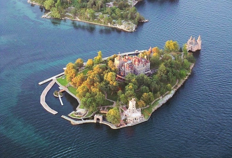
The Thousand Islands is an archipelago consisting of exactly 1,864 islands that straddles the Canada-U.S. border in the Saint Lawrence River as it emerges from the northeast corner of Lake Ontario. They stretch for about 80 km on St. Lawrence Seaway, but the largest clustering of islands falls between Cape Vincent and Alexandria Bay in the United States and Kingston and Rockport in Canada. The islands range in size from over 40 square miles to smaller islands occupied by a single residence, to even smaller uninhabited outcroppings of rocks that are home to migratory waterfowl. The number of islands was determined using the criteria that any island must be above water level all year round, have an area greater than 1 square foot, and support at least one living tree.
thousand-islands-3
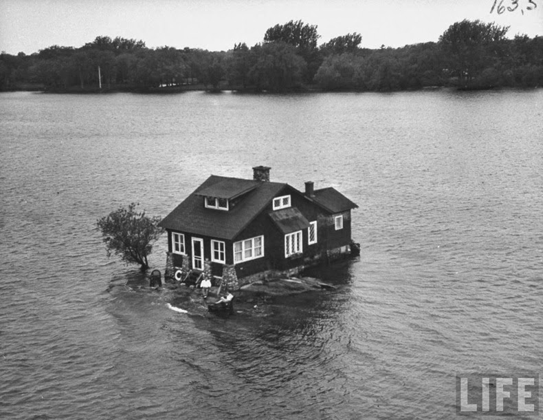
The Just Room Enough Island. Photo credit
The largest of these islands is Wolfe Island which is about 29 km long and 9 km at its widest point. It has a resident population approximately 1400 people. By comparison, the very aptly named “Just Room Enough“ is the tiniest island that squeezes a single house and a couple of wrought-iron benches pushed hard up against the shingles onto its banks.
A large number of these islands are inhabited, often bearing a single and at times a tiny house, and are serviced by ferry boats from the mainland. Today most of the islands boast of having hydro electric power and telephone service being carried by underwater cable from island to island.
Around twenty of these islands form the Thousand Islands National Park, the oldest of Canada's national parks east of the Rockies. The park hosts campgrounds, inland walking trails, annual family events, as well as a national heritage building. The Thousand Islands-Frontenac Arch region was designated a World Biosphere Reserve by UNESCO in 2002.
thousand-islands-1
Another view of Just Room Enough Island. Photo credit
thousand-islands-15
An undated picture of Just Room Enough Island. Photo credit: Life.com
thousand-islands-11
Aerial view showing some of the many islands of the Thousand Islands. Photo credit
thousand-islands-2
Boldt Castle, located on Heart Island in the Thousand Islands. Photo credit
thousand-islands-16
Photo credit: Ian Coristine
thousand-islands-8
thousand-islands-9
thousand-islands-10
thousand-islands-14
thousand-islands-4
thousand-islands-6
thousand-islands-7